Supermarket nearby ALDI
Netherlands
Supermarket nearby ALDI
ALDI
Malbergsingel 54, Maastricht Países Bajos
contacts phone
:
+31
Latitude:
50.864341
, Longitude:
5.655752
read more
nearest Supermarket
ALDI Maastricht - Malberg
Malbergsingel 54, Maastricht
Supermarket
read more
106 m
Jumbo Wijshof Malberg
Meierruwe, Maastricht
Supermarket
read more
111 m
Jumbo
Malbergsingel 74, Maastricht
Supermarket
read more
1.142 km
PLUS
Clavecymbelstraat 31-33, Maastricht
Supermarket
read more
1.142 km
PLUS Caberg
Clavecymbelstraat 31-33, Maastricht
Supermarket
read more
1.673 km
AH Brusselsepoort
Brusselsepoort 45, Maastricht
Supermarket
read more
1.673 km
Albert Heijn XL
Brusselsepoort 45, Maastricht
Supermarket
read more
1.722 km
't Rommedoeke Specialiteitenhuis
Brusselsepoort 37, Maastricht
Supermarket
read more
1.73 km
AH pickup point
Eenhoornsingel 89, Maastricht
Supermarket
read more
1.738 km
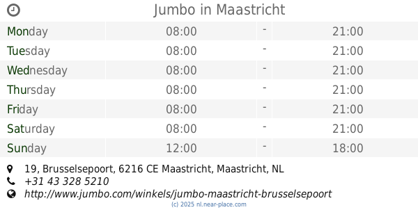
Jumbo
Brusselsepoort 19, Maastricht
Supermarket
read more
1.784 km
SPAR Veldwezelt
Kerkveld 48, Lanaken
Supermarket
read more
1.796 km
鶏肉屋さん De Hazendans
Heserstraat 18, Maastricht
Supermarket
read more
1.841 km
Yildiz Plaza
Holsteinbastion 49, Maastricht
Supermarket
read more
2.108 km
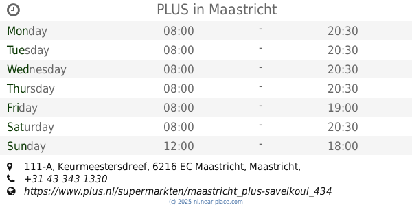
PLUS
Keurmeestersdreef 111-A, Maastricht
Supermarket
read more
2.297 km
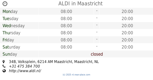
ALDI
Volksplein 34B, Maastricht
Supermarket
read more
2.505 km
Colruyt Lanaken
Kiezelweg 16, Lanaken
Supermarket
read more
2.707 km
Afrikana
Grote Gracht 55, Maastricht
Supermarket
read more
2.718 km
Onis
Stationsstraat 35, Lanaken
Supermarket
read more
2.734 km
Carrefour market
Molenweideplein 40, Lanaken
Supermarket
read more
2.777 km
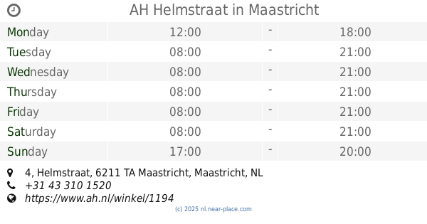
AH Helmstraat
Helmstraat 4, Maastricht
Supermarket
read more
2.818 km
Herman nachtwinkel
3620, Stationsstraat 2, Lanaken
Supermarket
read more
2.967 km
Jumbo
Laag Mosae Forum 26, Maastricht
Supermarket
read more
2.984 km
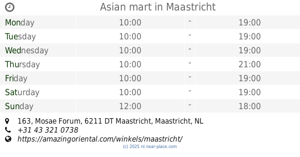
Asian mart
Mosae Forum 163, Maastricht
Supermarket
read more
3.17 km
Lidl
Maaseikersteenweg 197, Lanaken
Supermarket
read more
3.724 km
Supermarkt Cobben
Glacisweg 21, Maastricht
Supermarket
read more
📑
all categories
Accounting
Administrative area level 1
Administrative area level 2
Airport
Amusement park
Aquarium
Art gallery
Atm
Bakery
Bank
Bar
Beauty salon
Bicycle store
Book store
Bowling alley
Bus station
Cafe
Campground
Car dealer
Car rental
Car repair
Car wash
Casino
Cemetery
Church
City hall
Clothing store
Colloquial area
Convenience store
Country
Courthouse
Dentist
Department store
Doctor
Electrician
Electronics store
Embassy
Establishment
Finance
Fire station
Florist
Food
Funeral home
Furniture store
Gas station
General contractor
Grocery or supermarket
Gym
Hair care
Hardware store
Health
Hindu Temple
Home goods store
Hospital
Insurance agency
Jewelry store
Laundry
Lawyer
Library
Light rail station
Liquor store
Local government office
Locality
Locksmith
Lodging
Meal delivery
Meal takeaway
Mosque
Movie rental
Movie theater
Moving company
Museum
Natural feature
Neighborhood
Night club
Painter
Park
Parking
Pet store
Pharmacy
Physiotherapist
Place of worship
Plumber
Point of interest
Police
Political
Post office
Premise
Real estate agency
Restaurant
Roofing contractor
Route
Rv park, camping
School
Shoe store
Shopping mall
Spa
Stadium
Storage
Store
Subpremise
Subway station
Supermarket
Synagogue
Taxi stand
Train station
Transit station
Travel agency
University
Veterinary care
Zoo
administrative area level 3
administrative area level 4
sublocality level 1
sublocality level 2
↑