Restaurant nearby Croissantenzo
Netherlands
Restaurant nearby Croissantenzo
Croissantenzo
Rozenburgpad, Almere Holandia
contacts phone
:
+31
Latitude:
52.3603564
, Longitude:
5.1997764
read more
nearest Restaurant
20 m
Ontbijt in Almere
Rozenburgpad 4, Almere
Restaurant
read more
382 m
Eten en Drinken op het Plein
's-Hertogenboschplein 21, Almere
Restaurant
read more
732 m
Subway Almere
Omroepwg 1, Almere
Restaurant
read more
778 m
Het Hollandsche Huys Stedenwijk B.V.
Ermelopad 1, Almere
Restaurant
read more
890 m
Kalkoen Express
Musicalstraat 10, Almere
Restaurant
read more
909 m
PizzaBoss
Enschedepad 61, Almere
Restaurant
read more
926 m
Lin Wah
Rimsky-Korssakovweg 1, Almere
Restaurant
read more
929 m
Kwalitaria de Dirigent
Rimsky-Korssakovweg 41, Almere
Restaurant
read more
929 m
Snack Bistro De Dirigent
Rimsky-Korssakovweg 41, Almere
Restaurant
read more
953 m
Nieuwe Lin Wah
Bartokweg 127, Almere
Restaurant
read more
1.016 km
Restaurant Onderweg
Oorweg 3, Almere
Restaurant
read more
1.027 km
Easy Kitchen
Haarlemplein 1, Almere
Restaurant
read more
1.075 km
Eetcafe de Gooise Boer
Videostraat 4, Almere
Restaurant
read more
1.105 km
Spotlight
Amsterdamweg 1, Almere
Restaurant
read more
1.272 km
Grill Bar Jerusalem
Deventerpad 16, Almere
Restaurant
read more
1.287 km
Suja
Deventerpad 40, Almere
Restaurant
read more
1.29 km
Doner Plaza Muco
Deventerpad 32, Almere
Restaurant
read more
1.295 km
Altijd Lekker Almere
Deventerpad 8, Almere
Restaurant
read more
1.361 km
Snackcenter Kroon
Harpstraat 62, Almere
Restaurant
read more
1.792 km
Restaurant iDA
Grote Markt 157, Almere
Restaurant
read more
1.844 km
Alexandrie
71, Grote Markt, Almere
Restaurant
read more
1.916 km
Vermaat Winkels/Restaurants Holding B.V.
Hospitaalweg 1, Almere
Restaurant
read more
2.041 km
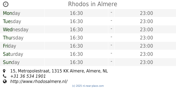
Rhodos
Metropolestraat 15, Almere
Restaurant
read more
2.114 km
Mediterrane Vis
Stationsplein, Almere
Restaurant
read more
2.118 km
HALAL 2GO
Stationsplein 5, Almere
Restaurant
read more
📑
all categories
Accounting
Administrative area level 1
Administrative area level 2
Airport
Amusement park
Aquarium
Art gallery
Atm
Bakery
Bank
Bar
Beauty salon
Bicycle store
Book store
Bowling alley
Bus station
Cafe
Campground
Car dealer
Car rental
Car repair
Car wash
Casino
Cemetery
Church
City hall
Clothing store
Colloquial area
Convenience store
Country
Courthouse
Dentist
Department store
Doctor
Electrician
Electronics store
Embassy
Establishment
Finance
Fire station
Florist
Food
Funeral home
Furniture store
Gas station
General contractor
Grocery or supermarket
Gym
Hair care
Hardware store
Health
Hindu Temple
Home goods store
Hospital
Insurance agency
Jewelry store
Laundry
Lawyer
Library
Light rail station
Liquor store
Local government office
Locality
Locksmith
Lodging
Meal delivery
Meal takeaway
Mosque
Movie rental
Movie theater
Moving company
Museum
Natural feature
Neighborhood
Night club
Painter
Park
Parking
Pet store
Pharmacy
Physiotherapist
Place of worship
Plumber
Point of interest
Police
Political
Post office
Premise
Real estate agency
Restaurant
Roofing contractor
Route
Rv park, camping
School
Shoe store
Shopping mall
Spa
Stadium
Storage
Store
Subpremise
Subway station
Supermarket
Synagogue
Taxi stand
Train station
Transit station
Travel agency
University
Veterinary care
Zoo
administrative area level 3
administrative area level 4
sublocality level 1
sublocality level 2
↑