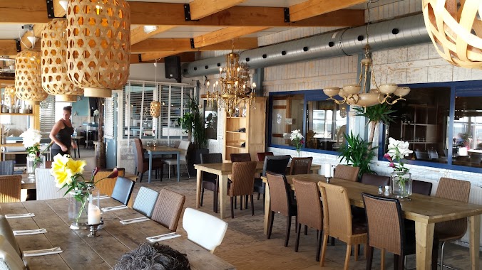
Restaurant nearby Brasil
Netherlands
Restaurant nearby Brasil
Brasil
Dorpsplein 12, Callantsoog Nederland
contacts phone
:
+31
Latitude:
52.8352411
, Longitude:
4.6931959
read more
nearest Restaurant
46 m
The 4 Seasons
Dorpsplein 13, Callantsoog
Restaurant
read more
49 m
Café De TAV
Dorpsplein 7, Callantsoog
Restaurant
read more
55 m
Wip-in
Dorpsplein 5, Callantsoog
Restaurant
read more
68 m
O3 Vis & Friet
Dorpsplein 17, Callantsoog
Restaurant
read more
86 m
Grand Cafe De Foyer
Dorpsplein 21, Callantsoog
Restaurant
read more
90 m
IEGEWIES eten & drinken
Dorpsplein 21b, Callantsoog
Restaurant
read more
206 m
Dorpszicht
Dorpsweg 2, Callantsoog
Restaurant
read more
211 m
Pizzeria Amore Mio
Dorpsweg 3, Callantsoog
Restaurant
read more
338 m
Strandpaviljoen Vos
Strandslag Seinpost, Dorpsweg 3e strandopgang vanuit Schagen, Callantsoog
Restaurant
read more
971 m
Restaurant Wereldwonder
Duinweg 4a, Callantsoog
Restaurant
read more
1.023 km
Strandpavilioen Zilte Zucht
Callantsoog
Restaurant
read more
2.306 km
Stal Horsecare
Zandweg 1, Callantsoog
Restaurant
read more
3.324 km
Brekers
Helmweg 9, Callantsoog
Restaurant
read more
3.348 km
De Princen Keet
Achterweg 2, Callantsoog
Restaurant
read more
3.964 km
China Wok Schagerbrug
Rijksweg 55, Schagerbrug
Restaurant
read more
4.043 km
The Mandarin
Oude Rijksweg 106, Het Zand
Restaurant
read more
4.366 km
Strandpaviljoen Noord
Sint Maartensvlotbrug
Restaurant
read more
4.596 km
Eeterij Drinkerij Duinerij
Westerduinweg 30, Sint Maartensvlotbrug
Restaurant
read more
4.838 km
Strandpaviljoen NewZuid Sint Maartenszee
Burgemeester Breebaartweg 1, Sint Maartensvlotbrug
Restaurant
read more
4.867 km
Restaurant De Goudvis
Zeeweg 91, Sint Maartensvlotbrug
Restaurant
read more
4.872 km
O3 Vis & Friet smz
De Zeeweg 83, Sint Maartensvlotbrug
Restaurant
read more
5.733 km
Rondom Gelukkig
Grote Sloot 351, Schagerbrug
Restaurant
read more
15.792 km
Afbeelding 1
Waarddijk Noord 2, Oudkarspel
Restaurant
read more
16.253 km
Luwe Stek viswater
Kanaal Kolhorn, Omval, Alkmaar
Restaurant
read more
16.279 km
De Luwe Stek Horeca
Hogebrugweg 11b, Waarland
Restaurant
read more
📑
all categories
Accounting
Administrative area level 1
Administrative area level 2
Airport
Amusement park
Aquarium
Art gallery
Atm
Bakery
Bank
Bar
Beauty salon
Bicycle store
Book store
Bowling alley
Bus station
Cafe
Campground
Car dealer
Car rental
Car repair
Car wash
Casino
Cemetery
Church
City hall
Clothing store
Colloquial area
Convenience store
Country
Courthouse
Dentist
Department store
Doctor
Electrician
Electronics store
Embassy
Establishment
Finance
Fire station
Florist
Food
Funeral home
Furniture store
Gas station
General contractor
Grocery or supermarket
Gym
Hair care
Hardware store
Health
Hindu Temple
Home goods store
Hospital
Insurance agency
Jewelry store
Laundry
Lawyer
Library
Light rail station
Liquor store
Local government office
Locality
Locksmith
Lodging
Meal delivery
Meal takeaway
Mosque
Movie rental
Movie theater
Moving company
Museum
Natural feature
Neighborhood
Night club
Painter
Park
Parking
Pet store
Pharmacy
Physiotherapist
Place of worship
Plumber
Point of interest
Police
Political
Post office
Premise
Real estate agency
Restaurant
Roofing contractor
Route
Rv park, camping
School
Shoe store
Shopping mall
Spa
Stadium
Storage
Store
Subpremise
Subway station
Supermarket
Synagogue
Taxi stand
Train station
Transit station
Travel agency
University
Veterinary care
Zoo
administrative area level 3
administrative area level 4
sublocality level 1
sublocality level 2
↑