Cafe nearby La Carambole
Netherlands
Cafe nearby La Carambole
La Carambole
Oortlaan 156, Veldhoven Nederland
contacts phone
:
+31
Latitude:
51.4129987
, Longitude:
5.3971643
read more
nearest Cafe
834 m
Buurthuis D'n Bond
BP, Rapportstraat 29, Veldhoven
Cafe
read more
1.035 km
Café de Sportvriend
Kromstraat 47, Veldhoven
Cafe
read more
1.054 km
Klijn Kooke Lunch & Koffieleuten
Kromstraat 40A, Veldhoven
Cafe
read more
1.072 km
Grand Café Saint Tropez
Dorpstraat 15, Veldhoven
Cafe
read more
1.093 km
"In d'n Olie-fant"
Kromstraat 29, Veldhoven
Cafe
read more
1.093 km
Café In d'n Oliefant
Kromstraat 29, Veldhoven
Cafe
read more
1.263 km
Café-Bar "De Locht"
Locht 14, Veldhoven
Cafe
read more
1.336 km
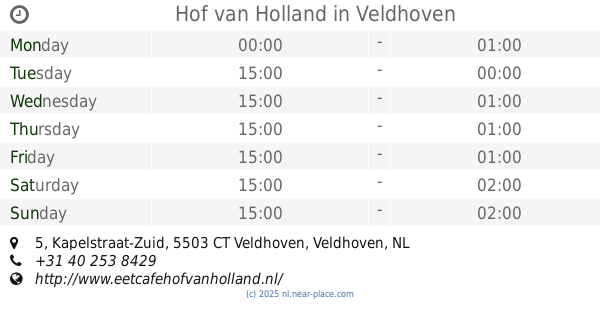
Hof van Holland
Kapelstraat-Zuid 5, Veldhoven
Cafe
read more
1.355 km
Party Pub Meerveldhoven
Mariaplein 12, Veldhoven
Cafe
read more
1.378 km
Café De Kleine Man
Kapelstraat-Noord 114, Veldhoven
Cafe
read more
1.625 km
Café-Restaurant De Leeuw
Provincialeweg 100a, Veldhoven
Cafe
read more
1.717 km
Café Change
Binnenweg 18-A, Veldhoven
Cafe
read more
1.798 km
Cafe zaal Sint Joris
Heuvel 7, Veldhoven
Cafe
read more
1.805 km
Centrum-Bar
Heuvel 5, Veldhoven
Cafe
read more
1.837 km
Manhattan
Kruisstraat 2, Veldhoven
Cafe
read more
1.841 km
't Stuupke
Blaarthemseweg 9, Veldhoven
Cafe
read more
1.886 km
Venn.O. Fa. Aarts & Loos Horeca Exploitatie
Kruisstraat 12, Veldhoven
Cafe
read more
2.296 km
Halong Bay Loempia's
Libel 83, Veldhoven
Cafe
read more
2.474 km
Warmoeskerken Beheer B.V.
Muggenhol 50, Veldhoven
Cafe
read more
3.176 km
W.J.M. van Loon
Bolestein 46, Eindhoven
Cafe
read more
3.996 km
Ijs & Koffie
Bredalaan 155, Eindhoven
Cafe
read more
4.07 km
Cafe Parrot Jack
Bredalaan 97, Eindhoven
Cafe
read more
5.03 km
Cafe Halve Maantje
Needestraat 2, Eindhoven
Cafe
read more
5.049 km
Babalu Bar
Hoogstraat 204, Eindhoven
Cafe
read more
6.573 km
Cafe de Barrier
Barrierweg 227, Eindhoven
Cafe
read more
📑
all categories
Accounting
Administrative area level 1
Administrative area level 2
Airport
Amusement park
Aquarium
Art gallery
Atm
Bakery
Bank
Bar
Beauty salon
Bicycle store
Book store
Bowling alley
Bus station
Cafe
Campground
Car dealer
Car rental
Car repair
Car wash
Casino
Cemetery
Church
City hall
Clothing store
Colloquial area
Convenience store
Country
Courthouse
Dentist
Department store
Doctor
Electrician
Electronics store
Embassy
Establishment
Finance
Fire station
Florist
Food
Funeral home
Furniture store
Gas station
General contractor
Grocery or supermarket
Gym
Hair care
Hardware store
Health
Hindu Temple
Home goods store
Hospital
Insurance agency
Jewelry store
Laundry
Lawyer
Library
Light rail station
Liquor store
Local government office
Locality
Locksmith
Lodging
Meal delivery
Meal takeaway
Mosque
Movie rental
Movie theater
Moving company
Museum
Natural feature
Neighborhood
Night club
Painter
Park
Parking
Pet store
Pharmacy
Physiotherapist
Place of worship
Plumber
Point of interest
Police
Political
Post office
Premise
Real estate agency
Restaurant
Roofing contractor
Route
Rv park, camping
School
Shoe store
Shopping mall
Spa
Stadium
Storage
Store
Subpremise
Subway station
Supermarket
Synagogue
Taxi stand
Train station
Transit station
Travel agency
University
Veterinary care
Zoo
administrative area level 3
administrative area level 4
sublocality level 1
sublocality level 2
↑