Cafe nearby Café Manilla
Netherlands
Cafe nearby Café Manilla
Café Manilla
Volksbondweg 23, Maastricht Holandia
contacts phone
:
+31
Latitude:
50.8470913
, Longitude:
5.6775117
read more
nearest Cafe
142 m
Cruts-Couriers
Proosdijweg 60, Maastricht
Cafe
read more
142 m
De Brusseleer Horeca-Beheer B.V.
Proosdijweg 60, Maastricht
Cafe
read more
325 m
Café Da Capo
Brusselsestraat 115, Maastricht
Cafe
read more
573 m
Ruyte2
Waldeckpark 1, Maastricht
Cafe
read more
649 m
Café de Poort
Oude Tweebergenpoort 8-B, Maastricht
Cafe
read more
680 m
Eetcafe de Preuverij
Kakeberg 6, Maastricht
Cafe
read more
750 m
Grand Café de Perroen
Vrijthof 34-35, Maastricht
Cafe
read more
841 m
Café de Capucijn
Capucijnenstraat 36, Maastricht
Cafe
read more
866 m
Kuzelj Beheer B.V.
Vrijthof 7, Maastricht
Cafe
read more
871 m
Café de Clochard
Grote Gracht 34, Maastricht
Cafe
read more
894 m
Horeca Hermans Maastricht
Platielstraat 9-A, Maastricht
Cafe
read more
896 m
Café Madrid
Bredestraat 18, Maastricht
Cafe
read more
904 m
Take Five
Bredestraat 14, Maastricht
Cafe
read more
946 m
café b.for
4, Sint Amorsplein, Maastricht
Cafe
read more
953 m
Grand Café La Porte
Brusselsepoort 66, Maastricht
Cafe
read more
997 m
Monkey Coffee
Markt 5, Maastricht
Cafe
read more
1.022 km
Caf‚ D‚fil‚
Markt 22, Maastricht
Cafe
read more
1.026 km
FM Kaffee
Markt 24, Maastricht
Cafe
read more
1.062 km
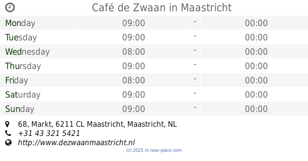
Café de Zwaan
Markt 68, Maastricht
Cafe
read more
1.07 km
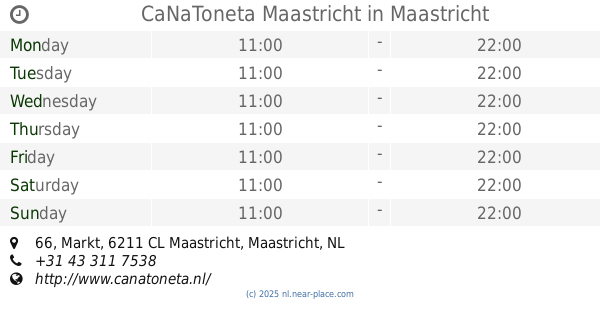
CaNaToneta Maastricht
Markt 66, Maastricht
Cafe
read more
1.075 km
Tijl Uilenspiegel
Markt 30, Maastricht
Cafe
read more
1.075 km
V.O.F. "D'n Dolle Dries"
Markt 31, Maastricht
Cafe
read more
1.125 km
Sway Café
Markt 39, Maastricht
Cafe
read more
1.147 km
Matuchi Oriental Style Lap
Kleine Gracht 34, Maastricht
Cafe
read more
1.352 km
G. Plass Exploitatie B.V.
Bassinkade 5, Maastricht
Cafe
read more
📑
all categories
Accounting
Administrative area level 1
Administrative area level 2
Airport
Amusement park
Aquarium
Art gallery
Atm
Bakery
Bank
Bar
Beauty salon
Bicycle store
Book store
Bowling alley
Bus station
Cafe
Campground
Car dealer
Car rental
Car repair
Car wash
Casino
Cemetery
Church
City hall
Clothing store
Colloquial area
Convenience store
Country
Courthouse
Dentist
Department store
Doctor
Electrician
Electronics store
Embassy
Establishment
Finance
Fire station
Florist
Food
Funeral home
Furniture store
Gas station
General contractor
Grocery or supermarket
Gym
Hair care
Hardware store
Health
Hindu Temple
Home goods store
Hospital
Insurance agency
Jewelry store
Laundry
Lawyer
Library
Light rail station
Liquor store
Local government office
Locality
Locksmith
Lodging
Meal delivery
Meal takeaway
Mosque
Movie rental
Movie theater
Moving company
Museum
Natural feature
Neighborhood
Night club
Painter
Park
Parking
Pet store
Pharmacy
Physiotherapist
Place of worship
Plumber
Point of interest
Police
Political
Post office
Premise
Real estate agency
Restaurant
Roofing contractor
Route
Rv park, camping
School
Shoe store
Shopping mall
Spa
Stadium
Storage
Store
Subpremise
Subway station
Supermarket
Synagogue
Taxi stand
Train station
Transit station
Travel agency
University
Veterinary care
Zoo
administrative area level 3
administrative area level 4
sublocality level 1
sublocality level 2
↑