Cafe nearby Starbucks
Coronavirus disease (COVID-19) Situation
confirmed cases
8635786
deaths
22992
Netherlands
Cafe nearby Starbucks
Starbucks
Stationsplein 10, Rotterdam Nederland
contacts phone
:
+31
Latitude:
51.9240443
, Longitude:
4.4694318
read more
nearest Cafe
58 m
StationsHuiskamer
Stationsplein 1, Rotterdam
Cafe
read more
350 m
Number Se7en
West-Kruiskade 7-B, Rotterdam
Cafe
read more
600 m
Café voorheen Companje
Teilingerstraat 89, Rotterdam
Cafe
read more
641 m
Café Coolsingel
Coolsingel 65, Rotterdam
Cafe
read more
662 m
Cinta Coffee
Coolsingel 83 1st floor (inside InConcept Store, Rotterdam
Cafe
read more
675 m
Café Bentinck
Bentinckplein 4, Rotterdam
Cafe
read more
676 m
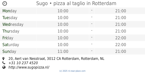
Sugo • pizza al taglio
Aert van Nesstraat 20, Rotterdam
Cafe
read more
711 m
DeKoffiebar
Karel Doormanstraat 352, Rotterdam
Cafe
read more
810 m
Raoul
Van Oldenbarneveltplaats 1, Rotterdam
Cafe
read more
821 m
Melief Bender
Oude Binnenweg 134, Rotterdam
Cafe
read more
823 m
Tapperij De Vijgeboom
Oude Binnenweg 146, Rotterdam
Cafe
read more
827 m
Café Timmer
Oude Binnenweg 120, Rotterdam
Cafe
read more
834 m
Brood & Zo
Oude Binnenweg 110-A, Rotterdam
Cafe
read more
835 m
Café Vanouds Vermeulen
Oude Binnenweg 120, Rotterdam
Cafe
read more
835 m
Café Verburgh
Oude Binnenweg 106-A, Rotterdam
Cafe
read more
861 m
Koekela B.V.
Nieuwe Binnenweg 79A, Rotterdam
Cafe
read more
933 m
Sajoer
Statenweg 141D, Rotterdam
Cafe
read more
938 m
Koffiehuis FES
Schietbaanstraat 25, Rotterdam
Cafe
read more
949 m
Café De Postbank
Schieweg 88-A, Rotterdam
Cafe
read more
1.048 km
Snackbar - Eetcafe - Restaurant Pizzeria Koekoek
Middellandplein 18A, Rotterdam
Cafe
read more
1.057 km
Nieuw Rotterdams Café
Witte de Withstraat 63, Rotterdam
Cafe
read more
1.066 km
Eetcafé Opa
Witte de Withstraat 49A, Rotterdam
Cafe
read more
1.128 km
Bar Loge 90
Schiedamsedijk 4, Rotterdam
Cafe
read more
1.142 km
Lounge & Café Asi
Schiedamsedijk 7-A, Rotterdam
Cafe
read more
1.291 km
Café Jacob Cats
Jacob Catsstraat 66-A, Rotterdam
Cafe
read more
📑
all categories
Accounting
Administrative area level 1
Administrative area level 2
Airport
Amusement park
Aquarium
Art gallery
Atm
Bakery
Bank
Bar
Beauty salon
Bicycle store
Book store
Bowling alley
Bus station
Cafe
Campground
Car dealer
Car rental
Car repair
Car wash
Casino
Cemetery
Church
City hall
Clothing store
Colloquial area
Convenience store
Country
Courthouse
Dentist
Department store
Doctor
Electrician
Electronics store
Embassy
Establishment
Finance
Fire station
Florist
Food
Funeral home
Furniture store
Gas station
General contractor
Grocery or supermarket
Gym
Hair care
Hardware store
Health
Hindu Temple
Home goods store
Hospital
Insurance agency
Jewelry store
Laundry
Lawyer
Library
Light rail station
Liquor store
Local government office
Locality
Locksmith
Lodging
Meal delivery
Meal takeaway
Mosque
Movie rental
Movie theater
Moving company
Museum
Natural feature
Neighborhood
Night club
Painter
Park
Parking
Pet store
Pharmacy
Physiotherapist
Place of worship
Plumber
Point of interest
Police
Political
Post office
Premise
Real estate agency
Restaurant
Roofing contractor
Route
Rv park, camping
School
Shoe store
Shopping mall
Spa
Stadium
Storage
Store
Subpremise
Subway station
Supermarket
Synagogue
Taxi stand
Train station
Transit station
Travel agency
University
Veterinary care
Zoo
administrative area level 3
administrative area level 4
sublocality level 1
sublocality level 2
↑